Why this beach is nothing like the southern resorts
Las Canteras is a genuine oddity in the Atlantic: a proper swimming beach inside a city of almost 400,000 people, walkable from half the capital. The reason sits underwater. About 200 metres offshore runs La Barra, a sandstone reef parallel to the shore that acts as a natural breakwater. It absorbs the north-westerly swell and leaves an inner bay where the water behaves more like a lagoon than open ocean.
That barrier does not cover the whole beach, and understanding this is the key to the place. Roughly the northern two thirds are sheltered; the southern third takes the Atlantic unfiltered. So within a twenty-minute walk you go from families floating in a metre of water to surfers taking head-high sets. The beach is not calm on some days and rough on others — it is two different beaches sharing one strip of sand.
The second difference from the beaches in the south is the shape of the day. In Maspalomas everything revolves around the sun; here it revolves around the city. Behind the sand runs an unbroken pedestrian promenade of cafés, terraces, shops and apartments, and the result is a beach that is still alive at nine on a Tuesday night in November. If you are torn between the capital and the south, our Maspalomas versus Las Palmas comparison goes through the trade-offs.
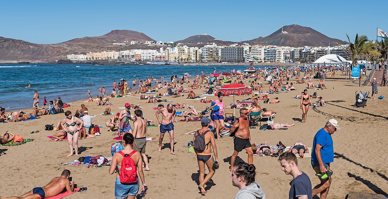
The three zones: choose before you lay down the towel
Locally the beach splits into three arcs, running north to south. Mixing them up is the classic visitor mistake: people who wanted a calm swim end up in the surf-school break, or surfers carry a board an extra kilometre.
| Zone | Approx. length | Water conditions | Best for |
|---|---|---|---|
| Playa Grande (north, up to La Puntilla) | ≈ 1,100 m | Very calm; sheltered by La Barra and La Isleta | Families, first swims, long swims |
| Playa Chica (centre) | ≈ 760 m | Calm, mixed rock and sand next to the reef | Snorkelling, rock pools at low tide |
| La Cicer (south, by the Auditorium) | ≈ 1,080 m | Open Atlantic, waves and rip currents | Surfing, lessons, sunset walks |
Playa Grande and La Puntilla
The northern end, at the foot of the La Isleta headland, is where the sand piles deepest and where the water shelves most gently. La Puntilla, the very tip, is effectively a swimming pool: sandy bottom, shallow for a long way out and barely any chop in moderate swell. This is the stretch families with small children choose, and the one used by locals swimming laps parallel to the shore before work.
Playa Chica
The central arc is the narrowest and the most interesting if you have a mask with you. The reef is close here and the bottom alternates rock and sand, so marine life gathers within a few metres of the shoreline. It is also the stretch that loses most sand at high water: on a spring high tide there are points where the sea reaches almost to the promenade wall.
La Cicer
Past the end of La Barra the beach changes character entirely. La Cicer, also known as Playa de Guanarteme, takes the swell head-on. The sand is darker, the currents deserve respect, and it holds the best urban surf break on the island. At the southern tip stands the Alfredo Kraus Auditorium, the lighthouse-shaped concert hall that closes the bay and is the easiest landmark for orienting yourself from anywhere on the beach.
Tides: the detail almost nobody checks, and it changes everything
In southern Gran Canaria the tide is a footnote. At Las Canteras it is the main variable of the day, because the Atlantic range here is around two metres and exceeds that on spring tides. Between low and high water the same beach offers two different experiences.
- At low tide La Barra emerges, parts of the reef can be walked with care, rock pools form between the rocks — the classic entertainment for city kids — and the strip of sand widens dramatically. It is the best window for beginner snorkelling.
- At high tide the reef is submerged, more swell works into the inner bay and some sections of Playa Chica lose their dry sand. Better for swimming distance inside the bay; considerably worse for planting a parasol.
Practical habit: look up the day's tide table before you leave, and plan around low water if you are bringing children or a snorkel, and around high water if the plan is to swim. In summer, go early as well — the trade wind builds through the afternoon and chops the water up.
The tidal rhythm at Las Canteras
The Canarian Atlantic runs on a semidiurnal cycle: two high waters and two low waters a day, roughly six hours and a quarter apart, each shifting a little under an hour later than the day before. The usual range at Las Palmas is about two metres, and on spring tides — around the new and full moon — it exceeds that. Two metres does not sound like much until you see it on a beach this gently sloping: the water advances and retreats by tens of metres across the sand.
| Tide state | Playa Grande and La Puntilla | Playa Chica and the reef | La Cicer |
|---|---|---|---|
| Low water | Very wide strip of sand; the sea is a long walk out | La Barra emerges and rock pools form; best snorkelling | More sand; the break moves away from the shore |
| Incoming tide | Clean water running in over warm sand | Good visibility and active fish | Usually improves for surfing |
| High water | You can swim straight off the shore | The reef submerges; more swell works in | Waves break close to the promenade |
| Outgoing tide | A gentle westward drift | Take care in the reef channels | Rip currents more pronounced |
Planning your day around the tide
- Snorkelling: the two hours either side of low water, on a calm sea, in the morning before the trade wind arrives.
- With children: low water again, at Playa Grande and La Puntilla, where the water stays ankle-deep for many metres.
- Swimming distance: better at high water inside the bay, when there is more depth and less exposed rock.
- Walking on the reef: only at low water, in water shoes and with no swell running; the rock is slippery and sharp.
- A parasol on Playa Chica: avoid a spring high tide, when the sea can reach almost to the promenade wall.
Checking today's tide
The exact times change daily. AEMET's official forecast for this beach covers sea state and tides: AEMET forecast for Las Canteras. The patterns on this page are stable; the clock times are not.
Swimming, snorkelling and what lives down there
Sea temperature sits around 19–20 °C in the coolest months and 23–24 °C by late summer, so swimming is a year-round proposition; in January and February a rash vest is welcome if you plan to stay still in the water. Visibility in the inner bay is reasonable most days, provided there has not been heavy swell in the preceding days.
With mask and snorkel along the inner side of the reef you can routinely expect sea bream, ornate wrasse — the emblematic green fish of the Canaries — big shoals of salema, octopus tucked into crevices and, with luck, cuttlefish. In winter the sandy bottom of the bay is one of the places where the angel shark turns up: a harmless bottom-dwelling species and one that is critically endangered. If you see one, watch from a distance, do not touch it and do not crowd it. It is protected, and the Canarian population is one of the last strongholds anywhere.
Basic safety: respect the flag system, do not swim out to La Barra when there is swell running — the current through the reef channels pulls harder than it looks — and do not get complacent at La Cicer just because the water is busy; the rip currents there are real. Las Canteras is a conventional family swimming beach: if you are looking for naturist beaches, they are covered in our guide to the nude beaches of Gran Canaria.
Surfing at La Cicer
La Cicer is where half the city learned to surf. It is a sand-bottomed beach break that works best on north-westerly swell, meaning autumn through spring; in summer it often goes small, which paradoxically makes it ideal for beginner lessons. Several schools operate with boards and instructors right on the sand, and the line-up gets crowded at weekends.
If you already surf, the local benchmark is El Confital, on the far side of La Isleta: a long, powerful right breaking over rock, with localism and no margin for error. It is not a spot to experiment on, and it is certainly not the logical step up from a first lesson at La Cicer.
The promenade, the food and the sunset
The Paseo de Las Canteras runs the entire length of the beach without a break. It is flat and built for walking: end to end and back is a comfortable six kilometres. Along it you get terraces, ice-cream places, hotels and a strip of restaurants where traditional Canarian cooking sits beside menus aimed squarely at visitors. As on any seafront in the world, the places with laminated five-language menus directly facing the water are rarely the best ones: two streets inland, towards the Guanarteme neighbourhood or Santa Catalina, you eat better and cheaper.
Facing west gives the beach something the south of the island cannot offer: the sun sets over the sea, straight ahead. In winter the sunset from up by the Auditorium, with the silhouette of Tenerife and Mount Teide on the horizon on clear days, is the best moment of the day here. Immediately behind the beach sit Parque Santa Catalina, the Poema del Mar aquarium and the Museo Elder — three indoor options worth knowing if the weather turns, all covered in our family attractions guide.
Getting there and parking
From the airport
Global route 60 is the direct connection: around 30 minutes for roughly €2.30–2.95. The useful stop for the beach is the Santa Catalina interchange, about five minutes' walk from the sand; San Telmo, the line's other stop, is further away beside Triana and Vegueta. Check before boarding that your service continues to Santa Catalina. Every alternative — taxi, private transfer, hire car — is compared in our airport transfers guide.
From the south of the island
From Maspalomas and Playa del Inglés, Global route 30 reaches Las Palmas by motorway in a little under an hour. A day trip without a car is entirely realistic: bus to Santa Catalina, beach in the morning, old town in the afternoon. Routes, tickets and the transport card are explained in the Gran Canaria bus guide.
Within the city
The yellow municipal buses cover the city frequently and many routes stop at Eduardo Benot, beside Parque Santa Catalina, a step away from the promenade. From Vegueta and Triana the ride is around fifteen minutes. It is worth pairing the beach with the old town: the Las Palmas Cathedral guide covers that other half of the city.
Parking
Be realistic here: free parking beside the sand on an August Saturday is not going to happen. What works is the paid underground car parks around Santa Catalina and near the Auditorium and the shopping centre at the southern end, plus time-limited blue-zone street parking. If you are staying in the capital, the practical advice is not to keep a car day to day and to hire one only for excursion days; our where to stay in Gran Canaria guide explains which parts of the city let you skip the car altogether.
Facilities, accessibility and practical tips
- All Gran Canaria beaches
- Lifeguards and first-aid posts along the beach during patrolled hours, with a flag system.
- Assisted bathing: walkways, ramps, amphibious chairs and a bathing assistance service for people with reduced mobility at signposted points. Availability depends on the season and the service's hours.
- Showers, toilets and sunbed and parasol hire spread along the promenade.
- Shade: scarce on the sand. In summer bring or hire a parasol; midday sun in the Canaries is stronger than the air temperature suggests.
- Wind: the trade wind usually arrives around midday. Mornings are calmer, with better water for snorkelling.
- Valuables: this is a busy city beach. Do not leave bags or phones unattended while you swim.
- Dogs: not permitted in the bathing area in season; check current municipal signage.
Frequently asked questions
Is it safe for swimming with children?
In the northern half, yes. Between Playa Grande and La Puntilla the reef leaves very calm water with a gently shelving sandy entry and lifeguards. La Cicer, in the south, sits beyond La Barra and has real waves and currents.
How much do the tides matter?
A lot. At low water the reef emerges, rock pools form and the sand widens; at high water the reef is submerged and some sections lose their dry sand. Check the tide table before picking a time and a zone.
Can you snorkel here?
Yes — one of the best urban snorkels in the Canaries. The inner side of the reef around Playa Chica holds sea bream, ornate wrasse and octopus. Best at low tide, on a calm sea, in the morning.
Where do you surf?
At La Cicer, next to the Alfredo Kraus Auditorium, where the schools are based. El Confital, beyond La Isleta, is a high-level right-hander and no place to learn.
How do I get there from the airport?
Global route 60, about 30 minutes and roughly €2.30–2.95. Get off at the Santa Catalina interchange, five minutes from the beach, and confirm your service goes that far.
Is there parking nearby?
Paid underground car parks at Santa Catalina and by the Auditorium, plus blue-zone street parking. Free parking beside the sand in high season is unrealistic.
Keep planning
- Gran Canaria travel guide
- Maspalomas or Las Palmas: where to base yourself
- Las Palmas Cathedral and the old town
- Dunes of Maspalomas
- Gran Canaria bus guide
More questions
Can you snorkel at Las Canteras?
Yes, and it is one of the best urban snorkelling spots in the Canary Islands. The inner side of the reef around Playa Chica and Pena la Vieja holds sea bream, ornate wrasse and octopus over mixed rock and sand. Conditions are best at low or incoming tide, on a calm sea, and in the morning before the trade wind picks up.
Is there parking near the beach?
There are paid underground car parks around Santa Catalina and near the Auditorium at the southern end, plus metered blue-zone street parking. Free parking beside the sand in high season or at weekends is unrealistic. If you are staying in the city, buses and taxis beat circling for a space.